If you live in Golden or you’re thinking about moving here, your commute is probably top of mind. You want options that are reliable, flexible, and easy to plan. The good news is you can mix rail, microtransit, bus, biking, and driving to tailor a door-to-door route that fits your life. In this guide, you’ll learn how the W Line, FlexRide, and key roadways work together so you can commute with confidence. Let’s dive in.
Where the W Line starts in Golden
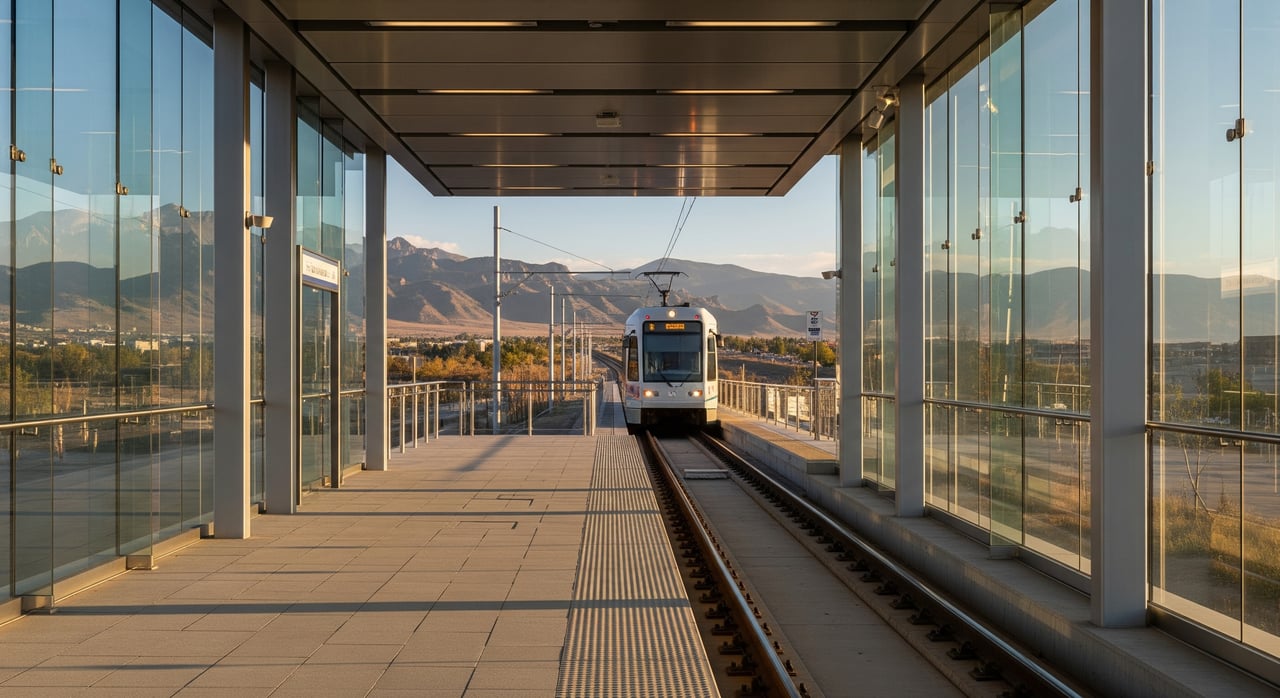
The W Line ends at the Jefferson County Government Center–Golden station, often called the Golden station. It connects Golden with Lakewood and Denver, including Union Station. The station sits next to the Jefferson County Government Center on the south side of town.
You’ll find typical end-of-line amenities like platforms, shelters, and signage. There is a surface park-and-ride area and short-term bicycle parking. If you plan to park regularly, confirm current rules and capacity with Jefferson County or RTD before you rely on it.
Many riders bike or drive to the station, then ride the W Line toward Denver. Others connect with local microtransit or a fixed-route bus for that first or last mile.
What to expect on the W Line
The W Line is designed for regional trips, with more frequent service during weekday peak hours and lighter frequency in the middle of the day, evenings, and weekends. Peak periods commonly run in the range of every 10 to 20 minutes on many RTD light-rail lines, while off-peak can stretch to every 20 to 30 minutes or more.
Plan on roughly 30 to 45 minutes from Golden to Denver Union Station, depending on stops, time of day, and any transfers. Actual times vary with operations and any track or street work. Give yourself buffer time for connections, and always check the current RTD timetable or a real-time tool for your specific departure.
FlexRide and local bus connections
FlexRide, sometimes called Call-n-Ride in certain areas, is RTD’s on-demand microtransit. It serves defined zones and is built to connect you from your neighborhood to major transit hubs like the Golden terminus.
- How it works: You book a ride within your zone and get picked up at a designated point or near your address, depending on the zone rules.
- What to check: Zone boundaries, operating hours, fares, and whether a reservation is required.
Fixed-route buses also connect parts of Golden to the station and to nearby destinations in Jefferson County. Frequencies and schedules vary, and some commuter routes offer timed connections during peak hours. Confirm route numbers, stop locations near your home, and whether a bus aligns with your W Line departure.
First and last mile options
If you are close to downtown Golden or central corridors, walking or biking can be a simple way to reach the station. Golden is bike-friendly for short to moderate distances, though some areas are hilly, so check your route and elevation.
For days when you’re carrying gear or the weather changes, rideshare, local taxis, or a neighborhood shuttle can fill the gap. Use what works for today, and keep backup options in your plan.
Driving and rail: a smarter combo
Golden has several major roadways that help you reach the station or other park-and-ride hubs:
- US-6 (6th Avenue): The primary surface route toward central and central-west Denver.
- CO-58: Links Golden to I-70 for faster freeway access to the east.
- CO-93: Runs north toward the Boulder area and the US-36 corridor.
- I-70 connections: Reachable via CO-58 or US-6 for regional trips.
Popular combos include driving from your neighborhood to the Golden park-and-ride and hopping on the W Line, or driving to another station or park-and-ride that fits your final destination or offers a better schedule. US-6 and CO-58 can be congested during peak hours, especially near I-70, so factor that into your drive-plus-rail time.
Commute tips by part of Golden
Every address is different, but these starting points can help you test the best route for your needs.
Downtown Golden
If you live near the historic core along Washington Avenue or the main downtown corridor, you’re a short bike ride or quick drive from the Golden station. Walking can work for some locations. The simplest plan is to bike or drive to the station and take the W Line. During bad weather or when you’re carrying extra items, a quick park-and-ride trip keeps things easy.
North Golden near CO-93
For homes closer to CO-93, a short drive on local streets or CO-93 can get you to the station. If a local bus or FlexRide zone serves your block, that can remove the need to park. If you’re commuting north toward the US-36 corridor, compare time on CO-93 with the W Line into downtown Denver and choose the option that gets you closer to your final stop with fewer transfers.
West and south Golden
Terrain is hillier toward Golden Gate Canyon and along parts of CO-58, which can make biking less practical. Driving to the Golden park-and-ride is common. Some neighborhoods may be covered by FlexRide zones, and rideshare can bridge the last bit to the station when needed. If your job sits along I-70 eastbound or requires freeway access, compare a direct drive on CO-58 to an eastbound park-and-ride versus taking the W Line.
Eastern neighborhoods near US-6
If you live near the US-6 corridor on the east side, you may have the choice of a quick car or bike ride to the station or using a bus route along US-6. For certain Denver destinations, an express bus on a nearby arterial could be faster than transferring from light rail. Check both options and pick what matches your schedule.
Plan your door-to-door time
A great commute plan starts with a simple comparison. Use this quick checklist to test your options for a typical weekday:
- Identify your target arrival time at work and your preferred departure window.
- Map three routes door to door: all-rail, rail plus FlexRide or bus, and drive plus rail. If needed, test a drive-only route as a baseline.
- For each route, note total time, transfers, and how much buffer you need. Include parking and walk time.
- Check current W Line headways for your travel period. Peak service is generally more frequent than midday or late evening.
- Confirm FlexRide zone hours and whether you need a reservation. If using a bus, check for timed connections to the W Line.
- If you plan to park, verify park-and-ride rules and whether lots tend to fill early.
- Save a backup plan for delays, like a later train, an alternate bus, or a rideshare to the station.
Run this exercise for both your morning and evening trips. Small changes in timing can make a big difference in total time and stress.
When the W Line shines
If you work near Union Station or central downtown, the W Line often gives you a predictable, no-traffic trip. You can read or catch up on email while the train moves you past congestion hotspots. During snow or heavy traffic days on US-6 and CO-58, rail can be the calmer choice.
If your office is outside the core, test combining the W Line with a last-mile bus, a short walk, or a rideshare from Union Station. For some destinations, driving to a different park-and-ride or using an express bus may be faster. The best answer is the one that fits your schedule, not just the map.
First-time rider tips
If you’re new to transit from Golden, a little prep goes a long way:
- Check the latest W Line schedule for your exact day and time. Service is more frequent during peak commute periods.
- Allow 10 to 20 extra minutes for transfers, especially in the evening.
- If you use FlexRide, verify the zone map, reservation process, and hours ahead of time.
- Test your bike route to the station on a weekend to learn the hills and timing.
- Keep a small “plan B” list in your phone for rideshare, a later train, or an alternate bus.
Parking, bikes, and security
Before you rely on the Golden park-and-ride, confirm current capacity and rules with Jefferson County or RTD. Lots can fill during peak periods and some have time limits. If you bike to the station, confirm the location of bicycle parking and consider a secure lock. If you prefer to bring a folding bike or use a bus bike rack on certain legs, build in a few extra minutes at first.
Driving-only days
Some days, driving the whole way may win. If you have multiple off-site meetings or a tight schedule with late returns, compare total time and flexibility. US-6, CO-58, CO-93, and I-70 give you options in every direction. Watch for peak congestion near I-70 and plan an earlier departure if you need a guaranteed arrival time.
Make your move with confidence
Choosing a home often comes down to how your daily life works, not just square footage. A clear commute plan can expand your search area and help you love where you live. Whether you prefer rail, FlexRide, or a hybrid approach, Golden gives you several viable paths to Denver and beyond.
If you want help aligning neighborhoods with your commute and lifestyle, we’re here to guide you with calm, local insight and practical options. Get your home valuation or schedule a consultation with Sold With Kathryn. You can reach us at Unknown Company.
FAQs
How the W Line connects Golden to Denver
- The W Line runs from the Jefferson County Government Center–Golden station to Denver, with more frequent service during weekday peaks and lighter off-peak service.
Typical W Line travel time from Golden
- Plan on roughly 30 to 45 minutes to Denver Union Station, and check the current schedule or a real-time tool before you go.
Using FlexRide for first/last mile in Golden
- FlexRide offers on-demand microtransit within defined zones that connect neighborhoods to the Golden station; confirm zone rules, hours, and reservations.
Parking at the Golden station
- The station area includes a surface park-and-ride; confirm current capacity and parking rules with Jefferson County or RTD before relying on it.
Driving routes from Golden during peak hours
- US-6 and CO-58 can be congested during peak periods near I-70; consider rail to bypass traffic or allow extra time if you drive.
Best options by neighborhood in Golden
- Downtown often favors walk, bike, or a short drive to the station; north, west, and south areas may lean on FlexRide or a park-and-ride depending on hills and distance.